Everyone is watching Iran right now.
The headlines track missiles, negotiations, proxies, and the nuclear programme. The cameras point at Tehran, at the northwest border with Iraq, at the Revolutionary Guard. The world has decided what Iran looks like and the image it has chosen is entirely political.
Nobody is watching Sistan-Baluchestan.
In January 2017 I boarded a bus in Zahedan — a dusty border city in Iran’s southeastern corner, three hours from Pakistan, four from Afghanistan — and rode it almost a full day to Chabahar on the Arabian Sea. The route covers roughly 700 kilometres through terrain that most Iranians have never seen and virtually no Western traveller has crossed overland.
This is what I saw through the window:
The Road Nobody Takes
Sistan-Baluchestan is Iran’s largest province and its least visited. It sits in the country’s southeastern corner, a place the tourist maps mark and then leave blank. The population is largely ethnic Baluch — a distinct people with their own language, their own traditions, their own relationship to a central government that has historically treated this region as peripheral.
Infrastructure arrives slowly here. The road between Zahedan and Chabahar was still being completed in places when I crossed it. Concrete underpasses were being built across the desert — not for traffic, but for flash flood water. Drainage channels for rain that might come once a decade and when it comes turns the desert floor into a temporary sea.
I was the only Western passenger on the bus.
The driver and the other passengers regarded me with the particular curiosity that arrives when a foreigner turns up somewhere foreigners don’t go. Not hostility. Something closer to genuine puzzlement. Why here? Why this road? I didn’t have a simple answer. I was crossing Iran overland because I wanted to understand what was between the borders, not just what was at them.
What was between them turned out to be one of the most extraordinary geological landscapes on earth.
A Different Planet
The Makran coast — the strip of land where Sistan-Baluchestan meets the Arabian Sea — sits directly above one of the most active tectonic boundaries on the planet. The Arabian tectonic plate is moving northward at approximately 4 centimetres per year, disappearing beneath the Eurasian plate in a process called subduction. The collision has been ongoing for tens of millions of years.
The results are unlike anything I had seen before or have seen since.
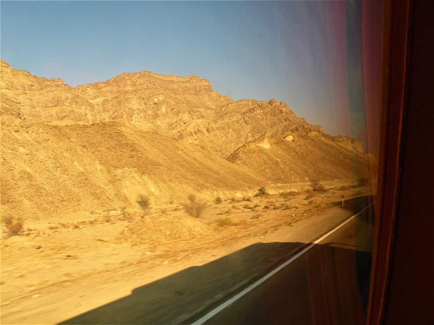
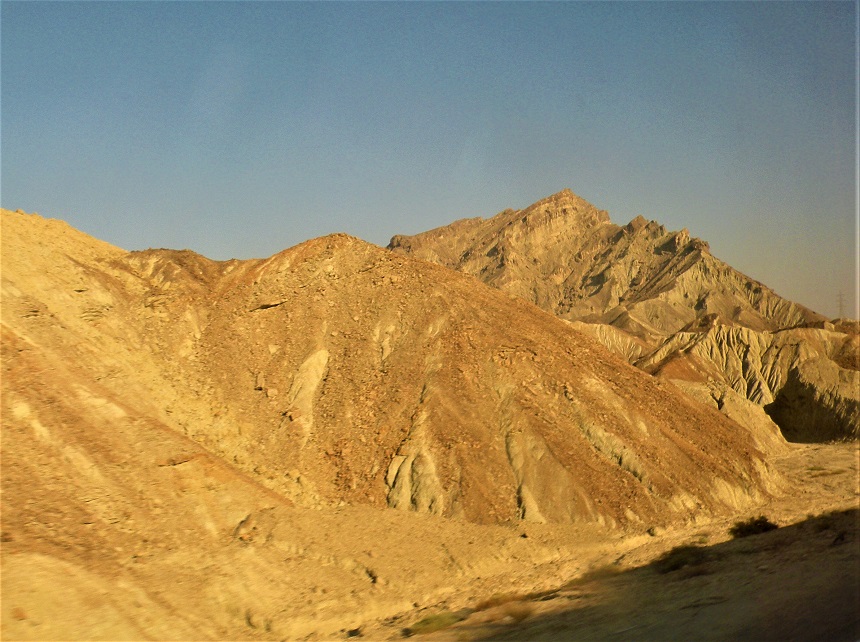
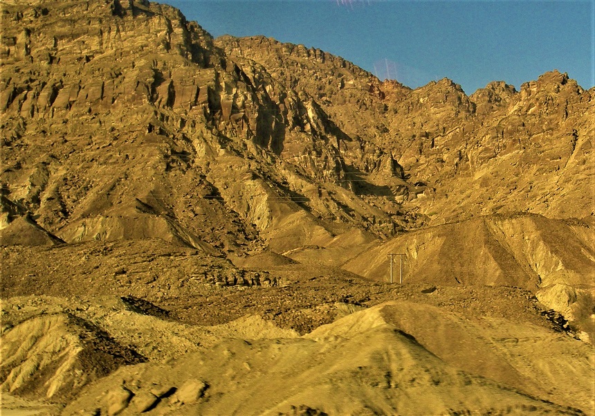
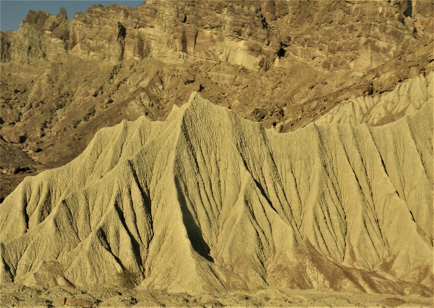
The mountains that appear through the bus window on this route are not the mountains of the Zagros — layered, folded, geologically mature. These are younger, stranger, more violent in appearance. The rock has been compressed and pushed upward faster than erosion can soften it. The ridges are sharp. The formations are twisted. The colours shift from yellow to ochre to grey to something approaching green depending on the mineral content of the layer you are looking at.

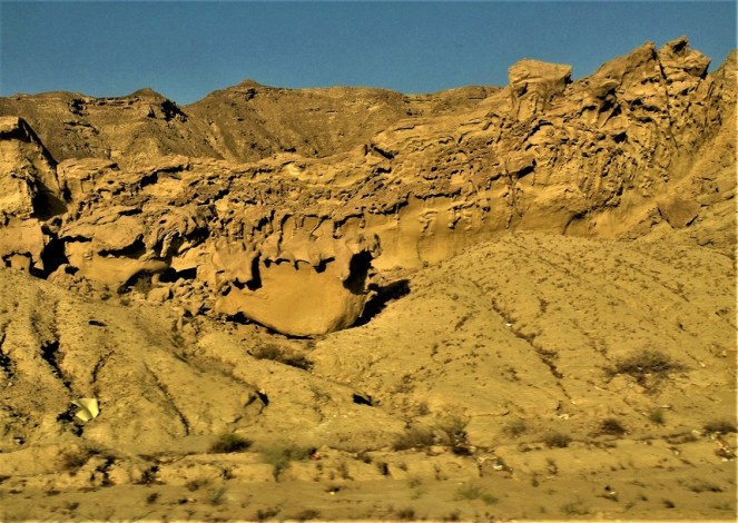
In places the terrain becomes what geologists call badlands — a landscape of mud and compressed volcanic ash so eroded by rare but catastrophic rainfall that it resembles nothing so much as the surface of another planet. NASA researchers studying Mars terrain have used Makran geological data as a reference point. Not as metaphor. As documented scientific methodology.
Everything visible in these photographs is documented at higher resolution on Google Earth and in published NASA geological surveys. The bus window was, if anything, the lower-resolution option.
I did not know any of this when I pressed the shutter. I just knew it looked like somewhere else entirely.
What the Photographs Show
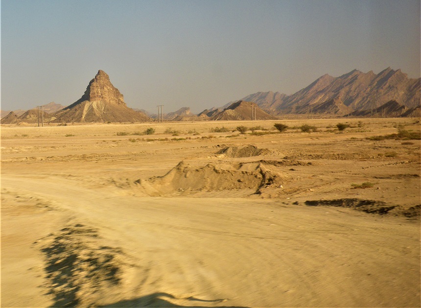
The first thing you notice from the bus window is the scale. The mountains rise directly from flat desert floor with no foothills, no transition, no warning. One moment: flat sand and scrub. Next moment: a wall of rock rising hundreds of metres, ridged and folded and ancient.
The light in January does something specific to this landscape. The sun sits low enough that the shadows fall horizontally across the rock face, picking out every fold and fracture. The result is a landscape that appears three-dimensional in a way that photographs struggle to capture — depth upon depth, layer upon layer, the geology of 50 million years compressed into a single view through dusty glass.
The mud volcano formations near Chabahar — locally known as Kuh-e Khajehi — are the strangest. The Makran coast has the highest concentration of mud volcanoes on earth. These are not volcanoes in the conventional sense. They are points where methane-rich sediment, compressed by the tectonic pressure below, pushes upward through the surface. The result is a field of erupting mounds, grey-brown, surrounded by the dried residue of previous eruptions. They bubble quietly. They have been bubbling for longer than human civilisation has existed.
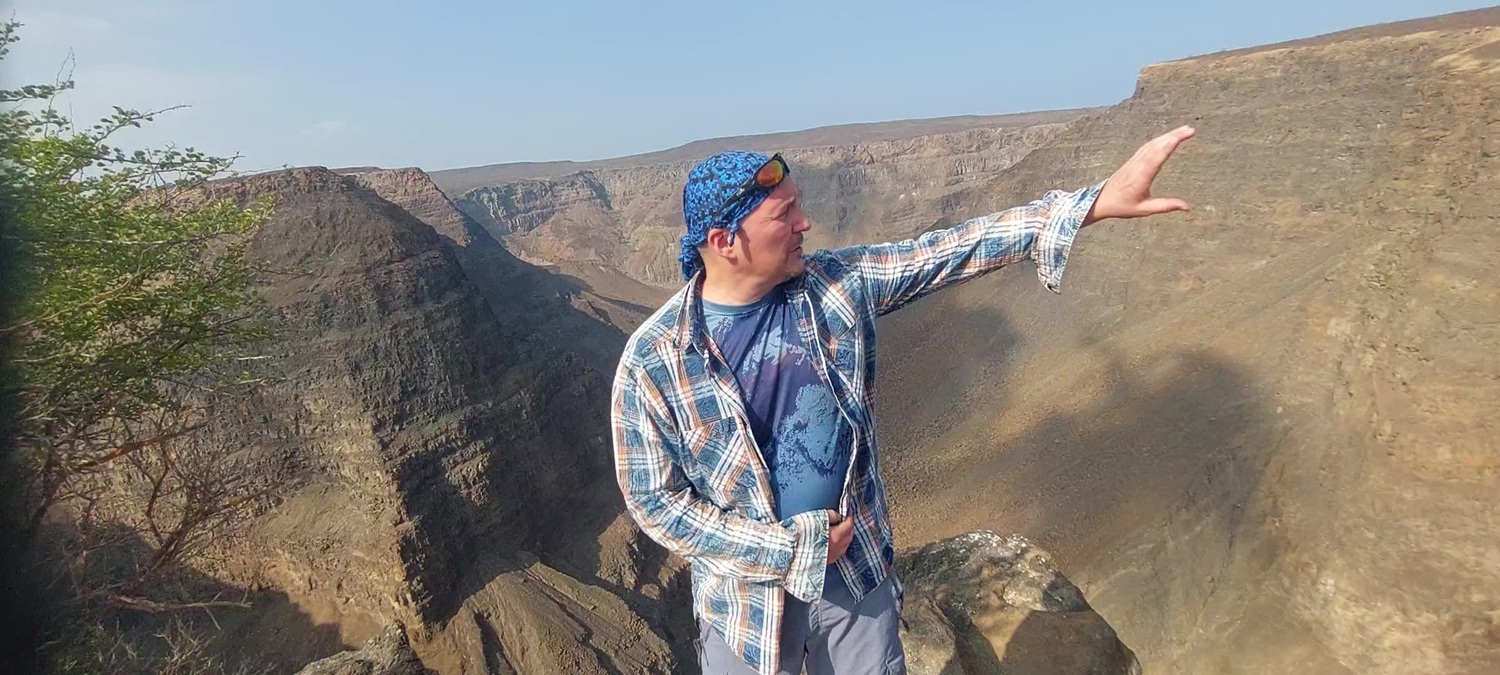
Standing beside one — which I did, briefly, when the bus stopped — you feel the earth moving in the most literal possible sense. Not an earthquake. Just the planet, doing what it does, indifferent to the bus schedule.
The Human Moment
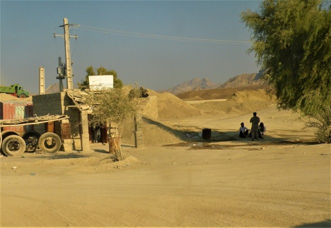
At a roadside stop somewhere between Iranshahr and the coast, the bus pulled over beside a rough structure — part workshop, part shelter, part home. Three people sat in the shade of a tree: a man standing, two others seated on the ground. A motorcycle wheel leaned against the wall. Power lines ran overhead toward somewhere out of frame. Mountains behind everything.
I photographed it through the window without them knowing.
This is Baluchestan. The people here are not Persian. They speak Baluchi — a language related to Kurdish and Pashto, carried westward from Central Asia centuries ago. They practise a form of Sunni Islam in a country where the official religion is Shia. They have their own music, their own embroidery, their own architecture, their own relationship to this desert that has nothing to do with the Iran of the headlines.
In a country that the Western imagination flattens into a single image, this photograph is a correction. Iran contains multitudes. The road from Zahedan to Chabahar runs through several of them.
Why This Place Matters Now
Chabahar is currently at the centre of one of the most significant geopolitical infrastructure projects underway anywhere in the world — and almost nobody in the Western press is covering it.
India has been developing Chabahar port as a strategic alternative to the Pakistani port of Gwadar — giving India access to Afghanistan and Central Asia without crossing Pakistani territory. China has been courting Iran for its Belt and Road Initiative. Iran’s government sees Chabahar as its gateway to the Indian Ocean and to the economic relationships that sanctions have denied it.
The city I reached after a day on a bus through the desert is now a node in a competition between major powers for influence across Asia.
None of this was visible from the bus window in January 2017. What was visible was a small port city at the edge of the Arabian Sea, dusty and unhurried, with fishing boats in the harbour and the smell of salt and diesel and distance.
The geological marvels I crossed to reach it will outlast whatever geopolitical arrangement is currently being negotiated. The Makran subduction zone does not care about sanctions. The mud volcanoes bubble regardless of who controls the port. The formations photographed through a bus window will still be there when the current headlines are historical footnotes.
Iran Offers More Than the Headlines Allow
I travelled to Iran because I wanted to see what was actually there — not what the news had told me to expect.
What was there: extraordinary hospitality from people who were consistently surprised and genuinely pleased that a foreigner had come, not to the obvious cities, but to the remote southeast. A landscape of geological violence and ancient beauty that most of the world has never seen and that no amount of political coverage will ever show. A province of ethnic and cultural complexity that the Iranian government’s own narrative tends to flatten as thoroughly as any Western news cycle.
And a bus that crossed it all in a single day, moving through terrain that felt — genuinely, not metaphorically — like the surface of another world.
The road from Zahedan to Chabahar is not on any tourist itinerary. It is not promoted by the Iranian tourism authority. It is not photographed by anyone with a professional camera or a significant following.
It is simply there. One of the most extraordinary drives on earth. Available to anyone willing to board a bus at dawn in a dusty border city and trust that what is between the borders is worth the crossing.
It is. Entirely. Whatever the headlines say.
